
Jewish Manchester, mapped
An interactive map of more than forty Jewish sites in Cheetham Hill, Strangeways and Hightown, launched in 2021 by Rachel Lichtenstein with oral history from Ros Livshin and Manchester Jewish Museum.
In October 2021, Manchester Metropolitan University launched the Memory Map of Jewish Manchester, an interactive map of former Jewish sites in Cheetham Hill, Strangeways and Hightown. Click a coloured circle and you get a photograph, a short oral-history clip, and a longer historical note. There are more than forty sites: shops, synagogues, schools, cinemas, cafés, streets and youth clubs. Some of the buildings no longer exist; the map still marks the spot.
Who made it
Dr Rachel Lichtenstein at MMU produced the project, assisted by Paul Darby. Dr Ros Livshin, oral historian of Manchester Jewry, wrote the site texts and supplied the audio, drawing on the Manchester Jewish Museum collections. Dr Duncan Hay developed the platform, the same open-source system first used for the Memory Map of the Jewish East End (2020), built with UCL’s Bartlett Faculty. Funding came from the Jewish Historical Society of England and MMU’s History Research Centre, with support in kind from the museum.
The museum says the project is finished and that it cannot add further sites itself. Themes on the map are Shops & Commerce, Community & Entertainment, Education, Streets, and Religion. There is also a text-only index.
The area the map covers
Jews have lived in Manchester since the eighteenth century. By the mid-nineteenth century a sizeable community from Central Europe, Eastern Europe and the Levant was established in Cheetham Hill. From the 1880s thousands of poor Yiddish-speaking refugees arrived after pogroms, economic hardship and forced conscription in the Pale of Settlement, often landing by boat at Hull, Grimsby or London and taking the train into Manchester. By 1900 the city had the largest Jewish settlement outside London.
Newcomers concentrated in Red Bank and Strangeways, in overcrowded housing that doubled as workshops. Most worked in tailoring or the garment trade. As people could afford it they moved out to Hightown and Higher Broughton. Later arrivals included refugees from Nazism in the 1930s, Holocaust survivors after 1945, and Egyptian, Hungarian and Iranian Jews in the 1940s and 1950s. Greater Manchester now has Britain’s second-largest Jewish population, about 35,000. The map concentrates on Cheetham Hill, Strangeways and Hightown, mainly between the wars.
Sites on the map
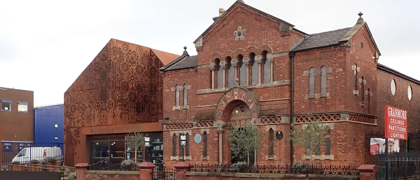
The Spanish and Portuguese Synagogue on Cheetham Hill Road was designed by Edward Salomons and opened on 6 May 1874 for Manchester’s Sephardi congregation, merchants from Aleppo, Cairo, Gibraltar and other Mediterranean ports. The first president was cotton exporter Isaac David Belisha, grandfather of Leslie Hore-Belisha. The synagogue closed in 1981 and reopened in 1984 as Manchester Jewish Museum. Audio on the pin includes memories of Sephardi melodies, top hats, and children coming downstairs under a canopy of tallitot for the priestly blessing at the end of Yom Kippur.
Titanics Deli began on Waterloo Road, Hightown, after Joseph Abraham Hyman survived the Titanic in steerage in 1912, spent months with relatives in New York, saw Jewish delis there, and returned to Manchester to open his own. His son’s interview on the map explains the name and the cellar where Hyman made sausages. Lapidus Chip Shop at 55 Bury New Road, run by Hyman and Annie Lapidus from around 1909, was a Saturday-night meeting place after Shabbat.
The Ice Palace on Derby Street opened in 1910-11 as Britain’s largest indoor rink, closed in 1915 to make observation balloons, and reopened in 1919. It hosted national skating championships and the 1924 World Championships, plus ice hockey. One interviewee recalls sneaking in as a child and falling in the water.
The Jewish Soup Kitchen began in February 1895 as a temporary kitchen organised by Michael Marks (of Marks & Spencer) and Rabbi Dr Berendt Salomon. A permanent kitchen opened in Lord Street in 1896; in 1906 it moved into Philanthropic Hall on Southall Street. It later became a Meals-on-Wheels service, run for decades by Dolly Phillips, and still operates from Prestwich. The hall itself survives in commercial use.
Cohen & Wilks manufactured weatherproof garments at Aquatight Mills on Derby Street from 1901. An interviewee who worked there as a cutter remembers being locked out until 8.30, and losing half an hour’s pay, if you were late for 8am. The Victoria Memorial Jewish Hospital on Elizabeth Street opened in 1904 so patients could get kosher food and care; it was backed by immigrant workshop masters and opposed at first by some anglicised communal leaders who feared it looked separatist. It joined the NHS in 1948 and closed in 1992, when a Jewish Victoria Wing opened at North Manchester General.
Visit
The map is free online. The museum is at 190 Cheetham Hill Road, the same Spanish and Portuguese building marked on the map.
The Spanish and Portuguese Synagogue at 190 Cheetham Hill Road is still the Manchester Jewish Museum. The map is at jewishmanchestermemorymap.org. The museum’s oral history collections are where most of the audio came from.